|
The prototype system has been already completed and now experiments
and improvements are repeated.
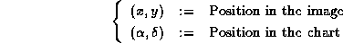
This prototype detects stars from the image, compares them to those in a
catalog and obtains the map function to convert the position in the
image to R.A., Decl.
We can see the finding chart of the same area as the original image.
The chart is created with data in a catalog and we can compare the two
on a display.
Here describes the method of star detection and matching in detail.
- Star detection
The process to detect stars from an image is as follows.
- Calculates a flatfield function
 . .
- Obtains a standard deviation
 of the difference between
each pixel value and the flatfield. of the difference between
each pixel value and the flatfield.
- On each pixel, if the value p is more than
 , the pixel is regarded as part of a star and the value is set as , the pixel is regarded as part of a star and the value is set as
 . If not, the value is set as 0. . If not, the value is set as 0.
- The pixels with non-zero value are seperated into some small
areas. Each area is regarded as a star and the system obtains the
coordinates of the center of gravity and total value of pixels in the
area as a brightness of the star.
Because the center of an image is brighter than the rims generally, the
flatfield function is expressed as a quadratic function of x,y:

The parameters  are obtained in the method of least squares. are obtained in the method of least squares.
The current software cannot seperate close double stars or clusters.
It cannot see if the object is widely diffused or is a linear noise,
either.
- Matching
Before matching, we have to determine the magnitude of detected stars
as properly as possible. The way of the current system is as
follows. First of all it picks up stars data from a catalog in an
approximately same area as the image. The data are sorted in magnitude.
The detected stars are also sorted in brightness. Then it allots the
magnitude to the brightness in order. That is, the magnitudes of detected
stars have some errors in this step.
The purpose of matching is to obtain a map function. A map function is
a coordinates converter to determine the position x,y in the image is
where in the chart created from a catalog. Definitely, after rotating
with an angle  and magnifying with rate k, the image should
correspond to anywhere in the chart. The difference between the two
coordinates is and magnifying with rate k, the image should
correspond to anywhere in the chart. The difference between the two
coordinates is  . The map function consists of
the four parameters. . The map function consists of
the four parameters.


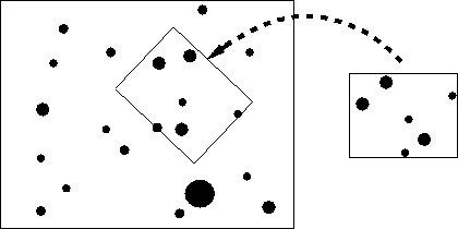
The map function is calculated with the following steps. First of all,
the system picks up three stars from the image and three stars from a
catalog. If the two trianles, which the selected three stars form, are
similar and the magnitudes of each corresponding pair of stars are also
similar, these three stars in the image may match to the three stars in
a catalog. So a map function between the two triangles is
calculated. These processes are tried to all combinations of trianles.
By the way, a true map function produces many similar triangles. It
means, the true value of map function is most often calculated in this
method. On the contrary, the function calculated with accidental similar
triangles is diffused and not calculated many times. Therefore the
system adopts the most overlapping parameters as a true map function.
Definitely, the parameter space is divided into some pieces with proper
intervals and the system counts how many times the parameters in each
pieces are calculated. Then it finds out the most overlapping piece.
The map function is obtained as a average of parameters in the piece.
This method strongly depends on the additional information input at
first. It assumes the approximate direction is absolutely in the
image. The true width of the image should be between the 0.67 times and
1.5 times of the approximate value. Even with the proper values, the
parameters of map function do not concentrate at one point and some
candidates of true function are often obtained. The large errors of
magnitudes alloted to the detected stars at the first step influence
much. However, when the approximate angle to rotate, for example when
the images are always taken as the north is up, only true map function
is obtained.
|